Chase Forecast 4/22/15
Let’s get right to it. The chase is on Weds (4/22/15) – Fri (4/24/15). For now, I am sticking to just Wednesday. I am trying to get a bit more technical, both my own benefit and yours if you’re reading. I will take it one day at a time, since significant severe weather could unfold each day. For your local area, please check the local NWS forecast, as well as the Storm Prediction Center.
Current Data:
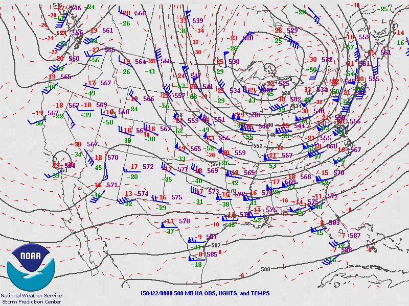
If we look upstream, we can find the embedded vort max that will be moving out onto the southern plains tomorrow. This will serve as a potential aid for surface based convection, and will likely yield at least some cyclogenesis across the southern plains.
500mb reveals a departing trough in the eastern US. A frontal boundary will slowly move south across Kansas/Oklahoma this evening. If you see the analyzed 500mb temps, you can also see some reflection of the wave across baja California, as circled (crudely) above.

Currently, moisture advection is underway in the southern plains. Let’s take a look at some soundings from OUN, DFW and AMA. We can see we have advected in a decent EML, given our source region over the desert southwest has been nice and dry. It becomes clear that with moisture advection overnight will “create” elevated instability. Overnight, with this moist advection, and impinging frontal boundary, beneath the profiles above, I would expect an MCS to form, with hints of this already happening, across the northern panhandle of Texas. This MCS would then move ESE across Oklahoma and the outflow from this/reinforcing of the boundary, will be a key player in tomorrow’s severe weather threat/location.
Looking at the 500mb flow, the background lapse rate environment and inbound moisture, we can see that on a large scale, a supercell environment will certainly be in place tomorrow across southern Oklahoma and northern Texas. Without even looking into a model forecast, we can guess a frontal boundary will sag south, possibly nudged further south by morning convection. We can also guess that a dryline will develop with some surface response to the inbound wave. Already, we can narrow the target area down to areas likely south of I40 in Texas and Oklahoma, further south into Texas, and somewhere likely east of the I27 corridor in Texas.
Before looking at any composite reflectivity, lets take a look at some point soundings across the area tomorrow! Let’s assume that the storms tonight push the frontal boundary well into southern Oklahoma. You will find if you have to guess one way or the other (north vs south), that south is usually a better guess for where a convectively enhanced boundary will end up. Looking at the soundings below, we can see moisture advection is continuing through tomorrow afternoon. Seymour, TX is a bit more moist and has not mixed as deep as Childress, TX further to the west. As we suspect, however, there is a decent EML that, if overcome, either by continued moistening/ascent along the frontal boundary, or near the dryline circulation, would create sufficient buoyancy. The LFC heights are a bit high, however. and would indicate that to me, you need to either 1), hug the frontal boundary and hope for moisture pooling and added ascent, or 2) hope for development further northwest in the panhandle where sufficient heating/mixing will take place. There is also some lingering clouds in the model which depending on if they occur, could hamper convection chances. If you made me pick right now, I think I would sit far northwest, near the dryline/front intersection, and await something in the relatively clearer/more unstable environment that is more likely to convect. Somewhere west northwest of Childress, TX?
3pm NAM4 Model Images:
By 00z, there should be a few storms ongoing already (hopefully). There will likely still be supercells, but I suspect upscale growth into an MCS is likely. This MCS could impact areas such as the DFW metro in the late evening hours. The soundings will get gradually better as the evening continues, but again, the trend for upscale growth will continue, so exact storm formation time, will depend on ultimate evolution.

Summary:
So, we now know we expect a dryline to form in the Texas panhandle, with a frontal boundary draped east/west somewhere across Oklahoma arcing back north into Texas. The exact location of the boundary will be influenced by convection this evening. The upper air pattern does not suggest a massive surface response, which means a lack of a super sharp dryline and potentially a lesser chance of true dryline initiation. We saw above that potentially, clouds could inhibit instability to some degree, with higher convective temperatures needed further east across the boundary in south central Oklahoma. This leads me to think that the best area for initiation may be further northwest near the front/dryline intersection, which should have the best chance to clear, destabilize and warm in the afternoon. With sufficient warming plus locally enhanced ascent along the boundaries, I would guess a storm goes up in this area.
Main Threats:
Weaker low level shear may slightly augment the tornado threat, but I believe with the boundaries in the area, this is certainly a threat! The main threat however, with ample shear and very steep lapse rates, will be VERY large hail. Once the storms transition to a complex, damaging winds will also become a strong concern.
Target:
This is where, if I had to look at just the 0z data, I would head. This is a bit west of the SPC outlooks, but this is just how I feel as of now.

High Res Model Radar Forecasts:
I know you want to see them, so here is a collection of images valid at 0z (7pm tomorrow).


